
On Tuesday night, the Hull Conservation Board unanimously agreed to install water sensors at various points along Hull’s coastline to monitor sea level rise.
WHOI believes Hull is well suited to test water sensors because coastal communities are vulnerable and provide an opportunity to better understand local flooding issues.
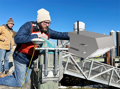
The water level sensors, which are expected to help scientists track sea level rise in coastal communities in Massachusetts, visited Hull in April and worked with Chris Krahforst, the city’s director of climate adaptation and conservation, to identify areas where Hull would place the sensors.
Committee members did not see any adverse effects from the installation of the sensors.
According to Das, installing sensors in the town will fill the gap between some people reporting flooding in their backyards and NOAA’s existing tide gauges, which have no connection to what the community is experiencing.
“There are only a handful of tide gauges in the entire Northeast, and the distance between observation areas is large,” Das said. “We need to deploy more sensors to understand water levels at a finer scale.” Even a small community can change; It may not be a major storm event, but it will produce flooding.
The National Oceanic and Atmospheric Administration’s tide gauge measures the water level every six minutes. The National Oceanic and Atmospheric Administration has six tide gauges in Massachusetts: Woods Hole, Nantucket, Chatham, New Bedford, Fall River and Boston.
Sea levels in Massachusetts have risen two to three inches since 2022, “which is much faster than the average rate observed over the last three decades.” That number comes from measurements from the Woodhull and Nantucket tide gauges.
When it comes to sea level rise, Das says, it’s this accelerating change in imbalance that drives the need for more data collection, especially to understand how this rate of increase will affect flooding on a localized scale.
These sensors will help coastal communities get localized data that can be used to mitigate flood risk.
“Where are we having problems? Where do I need more data? How are rainfall events produced compared to additional river runoff, compared to winds from the east or West? All of these scientific questions help people understand why flooding occurs in certain places and why it changes.” “Said Darth.
Das pointed out that in the same weather event, one community in Hull could flood while another would not. These water sensors will provide details not captured by the federal network, which monitors sea level rise for only a small portion of the state’s coastline.
In addition, Das said, researchers have good measurements of sea level rise, but they don’t have data on coastal flooding events. The researchers hope these sensors will improve understanding of the flood process, as well as models for allocating resources in the future.
Post time: Jun-04-2024