
Date: February 18, 2025
Location: Jakarta, Indonesia
As Indonesia grapples with its unique geographical challenges—from volcanic eruptions to flooding—the importance of advanced technology in disaster management cannot be overstated. Among the innovations making a significant impact is the use of hydrographic radar level meters. These devices are proving critical in enhancing flood monitoring, water resource management, and disaster preparedness efforts across the archipelago.
Understanding the Hydrographic Radar Level Meter
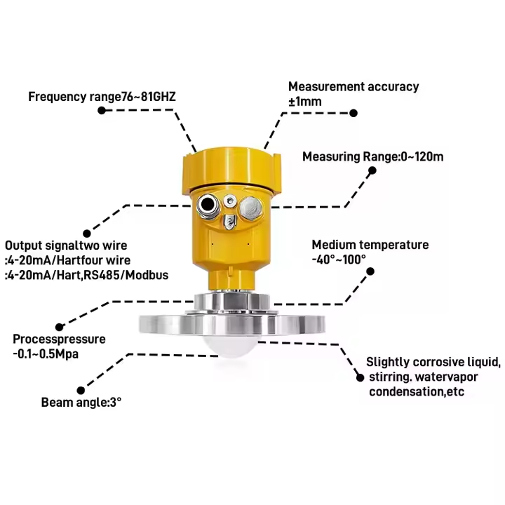
Hydrographic radar level meters use non-contact radar technology to measure water levels in rivers, lakes, and reservoirs. Unlike traditional gauges, which can be affected by debris and accessibility issues, radar level meters provide continuous, real-time data updates, ensuring that authorities have precise information on water levels at all times. This technology is particularly beneficial in a country like Indonesia, where diverse water bodies are spread across thousands of islands.
Enhancing Flood Monitoring and Response
Indonesia is particularly susceptible to severe flooding, especially during the rainy season. Floods can devastate communities, displace populations, and cause significant economic losses. In recent years, hydrographic radar level meters have become an integral part of Indonesia’s flood response strategies. By providing accurate and timely data on river levels, these devices enable disaster management agencies to issue flood warnings and mobilize resources effectively.
According to the National Agency for Disaster Management (BNPB), the integration of radar level meters into their monitoring systems has improved response times by over 30%. “When we know the water levels in real-time, we can predict flooding events much more accurately,” says Dr. Rudi Hartono, a senior meteorologist with BNPB. “This data helps us coordinate evacuations and deploy rescue teams where they are needed most.”
Supporting Water Resource Management
Beyond flood monitoring, hydrographic radar level meters play a vital role in water resource management—a crucial issue in Indonesia, where access to clean water can be inconsistent. The data collected by these devices supports the sustainable management of water infrastructure, ensuring that reservoirs and watersheds are monitored accurately.
For farmers and agricultural planners in rural areas, reliable data from hydrographic radar level meters can guide irrigation decisions and crop planning. With the variations in rainfall and climate patterns, having access to precise water level data helps ensure that agricultural production is optimized, mitigating the impacts of droughts or excess rainfall.
Disaster Preparedness and Community Resilience
Hydrographic radar level meters also contribute to community resilience in disaster-prone areas. Local governments and communities can integrate radar data into their disaster preparedness plans, ensuring that they are better equipped to deal with potential disasters such as floods. Training programs that include radar technology education have empowered local officials and communities to understand and utilize this data effectively.
In West Java, for example, community workshops are being held to educate residents on using radar data to monitor local rivers. This awareness fosters a proactive approach to disaster risk, enabling communities to act on warnings and reduce vulnerability. As one community leader explained, “We may not be able to stop floods, but we can prepare for them. The radar systems give us the information we need to respond sooner and save lives.”
Future Prospects
Looking ahead, the potential for hydrographic radar level meters in Indonesia’s disaster management landscape appears promising. Collaborations between governmental bodies, NGOs, and technological companies are expanding the deployment of these systems. Investments in infrastructure and training are crucial to ensure that this technology can be accessed by all regions, particularly those that are remote or underserved.
Moreover, ongoing research into integrating hydrographic radar systems with artificial intelligence and machine learning may provide even deeper insights into predicting flood events and other water management challenges. Improved forecasting capabilities could revolutionize the way Indonesia prepares for natural disasters, giving communities the tools they need to adapt to a changing climate.
Conclusion
As Indonesia faces an array of natural disaster challenges, the integration of hydrographic radar level meters into its disaster management framework has emerged as a crucial step forward. By enhancing flood monitoring, supporting water resource management, and fostering community preparedness, these devices are not only saving lives but also building a more resilient future for the nation.
In an era of climate uncertainty, the wisdom of investing in innovative technology like hydrographic radar level meters is clear. For Indonesia, these advancements are becoming essential pillars in the ongoing fight against the impacts of natural disasters, demonstrating that with the right tools and data, communities can turn vulnerability into resilience.
For more water radar sensor information,
please contact Honde Technology Co., LTD.
Email: info@hondetech.com
Company website: www.hondetechco.com
Post time: Feb-18-2025